Odby Sogn - Martrikelværk
Matrikelværk – Odby Sogn (1862)
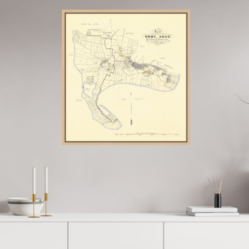
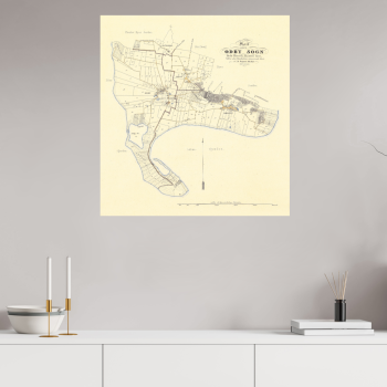
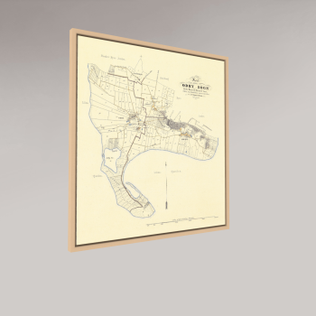
Dette historiske matrikelkort over Odby Sogn på Thyholm stammer fra 1862 og viser landskabet, som det tog sig ud i midten af 1800-tallet. Kortet er en del af de systematiske opmålinger, der blev gennemført i Danmark for at registrere jord, ejendomme og skel – og giver i dag et sjældent indblik i Thyholms landskab og bebyggelse i en tid, hvor livet var tæt forbundet med landbrug og fjord.
På kortet ses de enkelte gårdes jorder, husmandsbrug og de mange matrikler, der strukturerede landskabet omkring Odby. De fine linjer og tydelige skel fortæller historien om et lokalsamfund, hvor marker, engdrag og små veje bandt mennesker og jord sammen i et nøje organiseret mønster.
Thyholm ligger centralt i Limfjorden, og landskabet har gennem tiden haft både landbrugsmæssig og strategisk betydning. Under 2. verdenskrig blev området omkring Oddesundbroen, der forbinder Thyholm med Salling, udbygget med bunkeranlæg opført af den tyske besættelsesmagt for at kontrollere trafikken over fjorden. Sporene fra denne tid findes fortsat i landskabet i dag.
I dag fremstår Thyholm som et roligt fjordlandskab med små landsbyer, landbrug og åbne udsigter mod Limfjorden. Bag nutidens landskab ligger dog en lang fortælling om mennesker, jord og et lokalsamfund formet gennem generationer.
Se kortet i fuld opløsning
For at opleve alle detaljer i kortet kan du åbne en interaktiv visning i høj opløsning via SmartFrame:
→ Se kortet i fuld opløsning (åbner i nyt vindue)
Odby Sogn kort i fuld opløsning
Matrikelværket over Odby Sogn fremstilles som Fine Art print på Fine Art Velvet Balder kunstpapir (265 g) og tilbydes i flere udførelser.
Størrelser
Fine Art Print
S – 50 × 54 cm
M – 61 × 65 cm
L – 91 × 97 cm
Dibond Edition / Premium Indrammet
S – 50 × 54 cm
M – 61 × 65 cm
L – 91 × 97 cm
Udgaver
• Fine Art Print – løst giclée-print klar til indramning
• Dibond Edition – monteret på 3 mm Alu-Dibond med skjult ophæng
• Premium Indrammet – indrammet i massiv egetræ med refleksfrit glas eller museumsglas
Alle værker produceres i Danmark i samarbejde med professionelle Fine Art-trykkerier og indramningsværksteder.
Et historisk kort over Odby Sogn er ikke blot en gengivelse af et sted – men et stykke kulturhistorie, hvor landskab, mennesker og historie mødes i et grafisk værk skabt til væggen.
Cadastral Map – Odby Parish (1862)
This historic cadastral map of Odby Parish on Thyholm dates from 1862 and shows the landscape as it appeared in the mid-19th century. The map was part of Denmark’s systematic land surveys used to document property boundaries and land ownership.
The map reveals the farms, smallholdings and agricultural plots that shaped the rural landscape of Odby. The finely drawn boundaries and parcel structure illustrate how land and community were organised in a close relationship between people and the fjord landscape.
Thyholm occupies a central position in the Limfjord and has long held both agricultural and strategic importance. During the Second World War the area around Oddesund Bridge, connecting Thyholm with Salling, was fortified with bunkers built by the German occupying forces to control traffic across the fjord. Remnants of these structures can still be found in the landscape today.
Today Thyholm is known for its calm fjord scenery, small villages and open agricultural landscapes. Beneath the present-day landscape lies a long story of land, community and generations of local life.
View the map in full resolution
To explore all details of the map you can open the interactive SmartFrame viewer:
→ View the map in full resolution (opens in new window)
Odby Parish map in full resolution
The Odby Parish map is produced as a Fine Art giclée print on Fine Art Velvet Balder art paper (265 g) and is available in several formats.
Sizes
Fine Art Print
S – 50 × 54 cm
M – 61 × 65 cm
L – 91 × 97 cm
Dibond Edition / Premium Framed
S – 50 × 54 cm
M – 61 × 65 cm
L – 91 × 97 cm
Editions
• Fine Art Print – unframed giclée print ready for framing
• Dibond Edition – mounted on 3 mm Alu-Dibond with concealed mounting
• Premium Framed – framed in solid oak with anti-reflective glass or museum glass
All artworks are produced in Denmark in collaboration with professional Fine Art printing studios and framing workshops.
A historic map of Odby Parish is more than a representation of place – it is a piece of cultural history where landscape, community and history meet in a graphic artwork created for the wall.